Ila
1.1. It is said; the Vedic region broadly comprised three areas: Ila the western regions, Bharathi the tracts of the alluvial plains of the Ganga and Jamuna do-ab, and the third region being of course the Sindhu or the Sarasvati.
1.2. There is a view which asserts that ’Ila’, in fact, refers to the Land’s End of the Sothern India the parts of which were rescued from the Great Flood of the very distant past. It also mentions about the migration of people from the lands threatened by flood waters towards safe upper reaches and to regions in the North. The ancient texts such as Shatapatha Brahmana and the Puranas as also the ancient Tamil texts seem to support that view. Let’s talk of Ila of the South.
Yayathi and sons
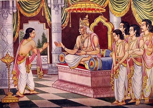
2.1. Yayathi the legendry king of the Vedic people is said to have had two wives: Devayani the daughter of Shukrachaya of the Bhrigu clan; and Sharmishta the daughter of Vrisha Parvan, the King of Asuras in the south west (Gujarat area) bordering the central region ruled by Yayathi. Vrisha Parvan too was a follower of the Bhrigus.
Devayani had earlier fallen in love, desperately, with Kaccha the son of Brihaspathi of the Angirasa clan. But her love was rejected.
2.2. Turvasha and Yadu were sons of Yayathi (an Angirasa) by Devayani of the Bhrigus; while Anu, Druhyu and Puru were his sons by Sharmishta of the Asuras.
2.3. Yayathi’s story indicates that the five great lines of Vedic rulers were born of an alliance of Deva and Asura kings, the followers of Angirasa and Bhrigu seers. Yayathi’s marriage with the Bhrigu women was perhaps an attempt to bring together the two rival clans.
2.4. According to Vishnu Purana (4.10.17-18) the king Yayathi divided his kingdom among his five sons . To Turvasha he gave the south-east; to Druhayu the west; to Yadu the south and west in the Narmada –Godavari region; to Anu the north; and to Puru the centre. Purus ruled as the Supreme king of all earth.
dhanāśā jīvitāśā ca jīryato ‘pi na jīryataḥ // ViP_4,10.17 //
pūrṇaṃ varṣasahasraṃ me viṣayāsaktacetasaḥ /
tathāpy anudinaṃ tṛṣṇā mamaiteṣv eva jāyate // ViP_4,10.18 //
2.5. In the lineage of the Puranas, the Purus and Yadus rule famously, for long years, as the prominent kings of Chandra-vamsha, the lunar dynasty. The descendents of Puru and Yadu branched into Pauravas and Yadavas, respectively. Dushyanata followed by his son Bharata was the pioneer of the Puru clan in which line descended the Kuru and Pandava princes. While, Krishna son of Yadava prince Vasudeva was the culmination of the Yadu clan.
The west and the south combine
3.1. Turvasha and Yadu, the two sons of Devayani of the Bhrigus were said to be twins; and were particularly close. The kings of the Dravida region were the descendents of Turvasha, while the kings of the island of Sri Lanka were Yadus. The regions ruled by the two clans stretched from the upper regions of the Narmada to the end of Southern land mass which perhaps extended beyond the present-day Sri Lanka. The entire region was ruled practically as one kingdom, because the ruling families in the South had very friendly relations with the Yadus of the Narmada region in the west. All were in the line of the Bhrigus.
3.2. The later legends mention of the sizable presence of the Asuras- Yadus – Brighus in the Narmada and Godavari region. It is said that Lavana, a Yadu and a disciple of the Brighus controlled that region. Lavana was related to Ravana who was a Yadu; a militant Yadu just as Kamsa of Mathura in the much later era. The followers of Lavana (including Ravana’s sister) roamed freely in the region. It was from this area that Ravana abducted Sita.
The Deluge and after
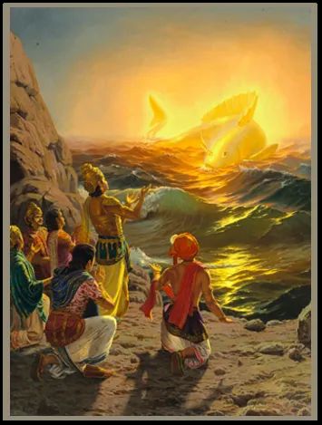
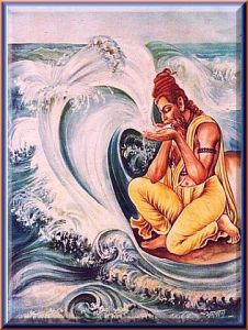
4.1. The Shatapatha Brahmana (I.8.1.1) describes the floods that swept the lands of the Vedic people, the rescue of the lands from the advancing floods; and of moving people and animals threatened by waters to the upper regions in the North. The other Vedic texts too carry similar legends of floods and the rescue. The later Puranas and Srimad Bhagavatam turned the great event associated with the rescue from the floods into the legend of Matsya-Avatara of Vishnu, his emergence as a Fish, the first of his ten principal incarnations.
manave ha vai prātaḥ | avanegyamudakamājahruryathedam
pāṇibhyāmavanejanāyāharantyevaṃ tasyāvanenijānasya matsyaḥ pāṇī āpede (I.8.1)
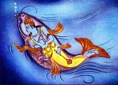
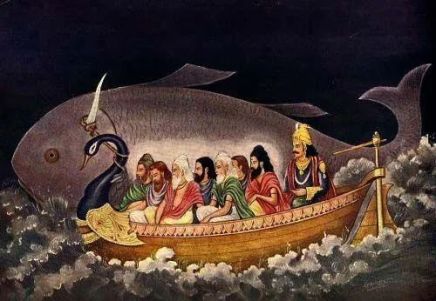
4.2.The Shatapatha Brahmana (I.8.1.5) says that a little fish (a shaphari crap fish) asked a king to save its life while he was performing his early morning- austerities standing in the river : and it kept growing bigger and bigger. The fish also informed the King of a huge flood which would soon hit and sweep away his land. The King thereafter built a huge boat to rescue his people, nine types of seeds, and animals in order to repopulate the earth. Accordingly, the king was taken to a Northern Mountain, where all were saved from the flood.
tamevam bhṛtvā samudram abhyavajahāra | sa yatithīṃ tatsamām paridideṣa tatithīṃ samāṃ nāva mupakalpyopāsāṃ cakre sa augha utthite nāva-māpede taṃ sa matsya
upanyā pupluve tasya śṛṅge nāvaḥ pāśam pratimumoca tenaitam uttaraṃ
girim atidudrāva 1.8.1.[5]
[H.S. Bellamy in his Moons, Myths and Men, estimates that altogether there are over 500 Flood legends worldwide. Ancient civilizations such as – China, Babylonia, Wales, Russia, India, America, Hawaii, Scandinavia, Sumatra, Peru, and Polynesia- each has its own version of a giant flood].

5.1. The common features of most (not all) of the Indian legends of the Great Flood are: The king who rescued the land and its people from the encroaching flood waters was Satyavrata of Bhrigu clan, perhaps a king in line of Yadu or Turvasha. He ruled in the Southern region — Dravida Desha. When the little fish jumped into his palms holding water as offering to gods, the king Satyavrata was standing in the waters of the river Kritamala flowing down from Malaya Hills .
Bhagavata Purana (8.24.12-13) also mentions that a fish jumped into the palms of King Satyavrata of Dravida Desha (Draviḍeśvaraḥ), holding water – Satyavrato añjaligatāṃ saha toyena Bhārata.
Tasyā añjalyudake kācic chaphary ekā abhyapadyata / Satyavrato añjaligatāṃ saha toyena bhārata / utsasarja nadītoye śapharīṃ Draviḍeśvaraḥ – BhP_08.24.012-13
After he built the boat, Satyavrata sailed north, away from the floods, and he rescued humans, nine types of animals and plants by taking them to safety in the regions of north and west.
Ila is the name of Satyavrata’s daughter; she is described as Maitra-Varuni (Brihadaranyaka Upanishad: 6. 4.28) suggesting she descended from the line of the Bhrigus. Ila is also the name of the land the parts of which were rescued from the flood waters.
athāsya mātaram abhimantrayate — ilāsi maitrāvaruṇī vīre vīram ajījanat |
sā tvaṃ vīravatī bhava yāsmān vīravato ‘karad iti
5.2. The Malaya hills mentioned in the legends refer to the ranges in the peninsular region of India stretching south from Sri Sailam to the southern end of the Western Ghats, which could be the border areas between the Nilgiri Hills and the Anaimalai Hills. An account of the pilgrimages undertaken by Sri Caitanya Mahaprabhu (1486–1534) mentions: “The Lord next visited the places known as Pandya-Desa, Tamraparni…, Panangudi, Carntapura, Sri Vaikuntha, Malaya-parvata and Kanya-kumari”. As regards the Kritamala River, it is believed to be the Vaigai River or its tributary. The river Kritamala is mentioned in Mahabharata in the context of Balarama’s pilgrimage: “After the Setubandha (Ramesvaram) Lord Halayudha then visited the Krtamala and Tamraparni (of the Tirunelveli district) rivers and the great Malaya Mountains”. Kritamala is also mentioned in the travel accounts of Sri Caitanya Mahaprabhu. Satyavrata might have therefore been a Yadu king of the Pandya country.
The king Satyavrata later became the progenitor of this eon: Vaivasvata Manu. He then was described as being in the line of the Vivasvan, an Aditya, a solar deity. Here too, Ila is his daughter.
The Rig Veda (I.31.11) mentions that Ila , the daughter of Manu was the first teacher to the sons of mortals. She is associated as a River, and also with Agni.
tvām agne prathamam āyum āyave devā akṛṇvan nahuṣasya viśpatim | Iḻām akṛṇvan manuṣasya śāsanīm pitur yat putro mamakasya jāyate || RV_1.031.11||
5.3. All these suggest that king Satyavrata came from the South (Draviḍeśvaraḥ). And, the lands and people rescued from the deluge were part of a large landmass called Ila or Ilavar or Ilam named after the daughter of king Satyavrata who became Vaivasvata Manu. The people rescued from Southern waters were moved to north and west. And, the Vedas existed before and after the deluge.
The Land of Ila
6 . 1. That fuels the argument that ancient Ila – mandalam ‘The Land of Ila’ lay to the South, and its Vedic- tradition of the Aryans was rescued by the efforts its king and his people. And thereafter , following a great migration, it rejoined the Vedic culture on the banks of the Saraswati River and flourished afresh. Since the rescue was by means of a huge boat that could sail over turbulent waters, the rescued population of the South could have reached the Saraswati basin by setting sail from a port situated along the west coast, nearer to the Pandya country. That possibility seems to give wings to the view that some of the early Vedic people in the Sindhu valley were migrants from Ila of the South; and that an early form of Dravidian language was one of the languages of the Indus people. Scholars assert that the Dravida influence was certainly present in north-western India by around the middle of the second millennium BC.
Shri Bhadriraju Krishnamurti in his ‘The Dravidian Languages’ Cambridge University Press, 2003 ; mentions that the Rig Vedic society consisted several different ethnic components who all participated in the same cultural life; and that the Rig Vedic Sanskrit had several borrowed-terms from the Dravidian e.g. ulukhala (mortar); kunda (pit); khala (threshing floor); kana (one eyed); and mayura (peacock).

6.2. A Russian Indologist, Nikita Gurov, claims that there were as many as eighty words of Dravidian origin in the Rig-Veda, ‘occurring in 146 hymns of the first, tenth and the other mandalas , e.g. RV 1.33.3, vaila (sthana-) -open space : wayal– open space , sunlight ; RV. 10.15, kiyambu –a water plant; RV 1.144, vril – finger: RV 1. 8.40, vilu- stronghold; witu – house, abode, camp; sira – plough; and kanuka –gift. Gurov also cites some proper names, namuci, kıkata, paramaganda; and suggests these could be of Dravidian origin.
6.3. The legends of Ila thus help to bind together the Vedic tales and the tales from the old Tamil texts.
The ancient Tamil legends
7.1. The ancient Tamil texts recall legends of a sunken kingdom that lay to the South-East of India. This land was known as Kumari Kandam ‘The Virgin Landmass’ or Ilam; and it included other parts of the now visible lands of Sri Lanka. That could be quite possible, since in the scale of geological time, the mountain ranges in the south-central Sri Lanka are regarded the oldest in the world. The geologists believe that these mountains existed while the Himalayan regions were still under water.
The Silappadhikaram, one of the Five Great Epics of Tamil Literature said to have been written in first few centuries BCE, states that the ‘cruel sea’ took the Pandiyan land that lay between the rivers Pahruli and the mountainous banks of the Kumari.
Adiyarkkunallar, a 12th-century commentator on the Silappadhikaram, explains that there was once a land to the south of the present-day Kanyakumari, which stretched for 700 kavatam from the Pahruli River in the north to the Kumari River in the south. the precise modern equivalent of a kavatam is not known. The speculations about the extent of the lands devoured by the ocean range from 6-7,000 square miles; or a smaller area .


(https://pparihar.com/2014/01/17/the-kumari-kandam/)
7.2. The deluge and its consequences caused large movements of people towards the upper regions in the north and to west. Early Tamil texts mention that the present-day Madurai came up as the new capital in remembrance of the old capital Ten-Madurai sunken underwater (the ruins of Ten-Madurai are supposed to be lying under water in the region of the Great and Little Bases in the Indian Ocean off the south eastern coast of Sri Lanka).
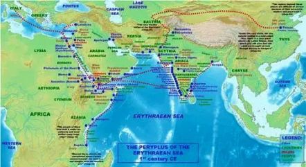
7.3. Even several centuries after its surrounding lands submerged under the sea , the author of The Periplus of the Erythraean Sea (dated around the first century) names the island of Sri Lanka as Palaisimoondus , which actually meant Palaya –ila- mandalam, meaning the old-land – of Ilam.
(please see the map or click here for an enlarged version).
[ After a deadly tsunami hit the coast of Mahabalipuram on 26 December 2004; and, uncovered some stone remains of a structure , the BBC, on 11 February 2005 , reported that the Archaeologists believe these could be the remains of an ancient port city that flourished off the coast in southern India, housing the famous 1200-year-old rock-hewn temple.]
Sage Agastya
8.1. The sage Agastya a revered seer of the South was the brother of sage Vasistha. The two are described as Bhrigus and carried the name Maitra-varuni; say like, Agastya Maithravaruni. The Puranas describe them as born out of water (children of Varuna), perhaps to suggest that the brothers escaped the flood waters and sailed out of it.
The brothers helped in controlling the floods and in rescuing the people. Thereafter Vasistha sailed back north along with the rescued people, while his brother Agastya stayed in the South. He then settled down at an ashram in the lower regions of Western Ghats.
Vasistha seemed to have enjoyed his voyage back home and recalls the happy days on board the ship:
“Boarding the ship, when Varuna and I entered the mid-ocean and floated with other vessels on water we indeed very much enjoyed the delightful rocking of the ship “(RV 7. 88. 3-4).
ā yad ruhāva varuṇaś ca nāvam pra yat samudram īrayāva madhyam |
adhi yad apāṃ snubhiś carāva pra preṅkha īṅkhayāvahai śubhe kam |7,088.03|
vasiṣṭhaṃ ha varuṇo nāvy ādhād ṛṣiṃ cakāra svapā mahobhiḥ |
stotāraṃ vipraḥ sudinatve ahnāṃ yān nu dyāvas tatanan yād uṣāsaḥ |7,088.04|
8.2. Agastya seems to have been a remarkable sage. He is described as ‘born small, not more than a span in length”; nonetheless he travelled from north to south along with eighteen groups of disciples chartering a new land route to South; and for that feat, he was accorded the epithet Vindhya-kuta, the one who tamed the Vindhyas . Until then, the chain of the Vindhya mountains, though by no means as impressive as the Himalayas, formed a formidable barrier between the North and the peninsula . And, the people were forced to use mainly the rivers or the coast to move about within the sub-continent. There were of course no regular roads during those times; and travel by land routes was very hazardous. The position remained so until about late 19th century.
[The Sea route

I reckon even the people of Harappa used the river or canal transport wherever expedient. With Himalayas being a vast stretch of high mountains, horribly cold and inhospitable, India’s trade and contacts with other countries had to be mainly through the sea routes, particularly through the ports along its west coast. Even during the earliest periods, it is said, the Brigus who dwelt in the Indus and the lower Narmada valley were great navigators, expert mariners, and enterprising tradesmen who controlled the trade between India and the peoples to its west, such as the Assyrians.
[As Prof. AL Basham mentions in his monumental work – The Wonder That Was India- :
The importance of the mountains to India is not so much in the isolation which they give her, as in the fact that they are the source of her two great rivers. The clouds drifting northwards and west¬ wards in the rainy season discharge the last of their moisture on the high peaks, whence, fed by ever-melting snow, innumerable streams flow southward, to meet in the great river systems of the Indus and the Ganges. On their way they pass through small and fertile plateaux, such as the valleys of Kashmir and Nepal, to debouch on the great plain…
The roads were dangerous to the merchant-caravans. Many of the trade routes linking centers of civilization passed through dense jungle, and over hills where wild tribes dwelt. ..The great rivers were used to carry both goods and passengers in vessels large and small. Chief of these was the Ganges, the artery of the Great Plain, but the Indus and the rivers of the Deccan were also important as trade routes.
*
The chief ports of ancient India were on the West Coast—Bhrgukaccha, Supara, not far from the modern Bombay, and Patala, on the Indus delta. Hence coastal shipping plied to the South and to Ceylon, and westwards to the Persian Gulf and the RedSea until, in the 1st century a.d., seamen took to using the monsoon winds to sail straight across the Indian Ocean to the ports of South India. In the East the Ganges Basin was served by the river port of Campa, from which ships sailed down the Ganges and coasted to the South and Ceylon.
The merchants and seamen of Roman Egypt knew India well, and there survives a remarkable seaman’s guide, compiled in Greek by an anonymous author towards the end of the 1st century a.d.. The Periplus of the Erylhrean Sea. From the Periplus, Ptolemy’s Geography, of the following century, and the early Tamil poems which look back to this period, we learn much of the trade of the Tamil lands. Here many flourishing ports are mentioned, the three chief being Muziris (Ancient Greek: Μουζιρίς, Malayalam: Muciri or Muciripattanam possibly identical with the medieval Muyirikode) , in the Cera country (Malabar), Korkai, in the land of the Panclyas, not far from the modern Tuticorin, and Kavirippattinam, the chief port of the Cola country, at the mouth of the Kaviri.
In the early centuries of the Christian era maritime trade became most vigorous, especially with the West, where the Roman Empire demanded the luxuries of the East in great quantities. With the fall of the Roman Empire the trade with the West declined somewhat, though it was maintained by the Arabs, and improved gradually with the rising material standards of medieval Europe. Before the time of the Guptas contact was made by sea between South India and China, and as trade with the West declined that with China increased, the Chinese demand for Indian spices, jewels, perfumes, and other luxury commodities continuing down to the present day]
****
The ancient Indian naval ships protected trade and carried troops to war zones. Kautilya (c. 4th century BCE) in his Arthashastra mentions the protection of the kingdom’s shipping and destruction of those threatening it, such as pirate ships (himsrika). However, while Kautilya devotes many pages on to how to fight on land and on wartime espionage and siege warfare, he is completely silent on naval warfare. While the army and forts are part of the seven constituents (saptanga) of a king’s sovereignty, without which he could not call himself king, the navy is not. The navy created by Chandragupta Maurya (321 BCE – 297 BCE) thus most likely performed these coast guard functions in keeping with Kautilya’s views.
In the Mauryan Empire where the 30-member war office was made up of six boards, the first board looked after shipping and was headed by the navadhyaksha (Superintendent of Ships). The navadhyaksha is tasked by the Arthashastra with examining accounts related to navigation and maintaining security over different kinds of water bodies. He is not given any direct military role. No naval battle fought by the kingdom of Magadha (6th century BCE – 4th century BCE), the Mauryas, or any other succeeding dynasty like the Guptas (3rd century CE – 6th century CE), has as yet come to light. Neither do the contemporary works elaborate on or discuss in detail the naval aspect of warfare.
The main aim was thus to protect maritime trade, merchant ships, port towns, and shipping in general. Any naval operation, whenever carried out, would have been very small-scale and on inland rivers rather than the high seas, since the maritime trade of most of these kingdoms was through rivers. The navy, when created by a dynasty based in the landlocked northern or eastern parts of India, does not seem to have been used aggressively or for conquest. In case of the Guptas and later dynasties, ships did exist as part of the army, but their use was much limited and not as extensive as the land forces. They were mostly used to conquer islands, as has been presumed for the campaign of the Gupta emperor Samudragupta (335 CE – 380 CE), or for fighting seafaring peoples as the Satavahanas (1st century BCE – 2nd century CE) did.
In the western, southern, and (coastal) eastern parts of India, the situation was markedly different. Being situated on the sea coast, the dynasties there relied heavily on maritime trade and the sea and built navies that were used in war. To them, the navy was an essential part of the military establishment along with the land forces. It was in these parts and the adjacent high seas that ancient India saw most of its naval warfare in practice. The most compelling reason was the capture of the highly lucrative foreign trade of the enemy; it was necessary to destroy the navy that protected it. Combined with land warfare, war on the sea became a prerequisite for defeating the seafaring enemy.
The dynasties which had well-developed navies were:
-
- Mauryas (4th century BCE – 2nd century BCE)
- Pallavas (3rd century CE – 9th century CE)
- Cholas (4th century BCE – 13th century CE)
- Early Cheras (3rd century CE – 9th century CE)
- Later Cheras or Kulashekharas (9th century CE – 12th century CE)
- Chalukyas of Vatapi (6th century CE – 8th century CE)
- Palas (8th century CE – 12th century CE)
Western coast
Local dynasties like the Mauryas of Konkan maintained a navy as well as coastal forts. The navy of the Early Cheras was developed to protect trade as most of the ports involved in international trade, particularly with Rome, fell under Chera territory. This fleet was extensively used in fighting foreign (exact identity unknown) pirates and against the rival kings supporting them. The Later Cheras or the Kulashekhara dynasty continued this naval tradition. Their war fleet was stationed near Kandalur Salai (modern-day Valiasala, Kerala state). Port towns, such as Vizhinjam (present-day Vizhinjam, Kerala state), were also heavily fortified. The Vatapi Chalukyas maintained a vast fleet that was used to transport thousands of troops to the war zones on land.
Southern & south-eastern coast
The Cholas, in time, became ancient India’s leading naval power. Beginning with Raja Raja I (985 CE – 1014 CE) who triumphed over the fleet of the Kulashekhara king Bhaskara Ravivarman I (962 CE – 1019 CE), successive Chola kings destroyed the Kulashekhara fleet off Kandalur Salai, conquered islands such as Lakshadweep (part of India) and the Maldives, and sent overseas expeditions to Sri Lanka and Southeast Asia.
The existence of the navy did not always help either. Despite being the prime maritime power, the Cholas were beaten many times on land by land-based powers such as the Rashtrakutas (8th century CE – 10th century CE) and the Kalyani (Western) Chalukyas (10th century CE – 12th century CE). As these powers existed outside the Chola naval zone of influence and operation, the navy could not be used against them and thus could not help in avenging or preventing the disastrous losses on land.
Ships & crew
The ancient Indians had a good knowledge of the materials, varieties, and properties of wood which went into the making the different classes of ships. The Yuktikalpataru written by King Bhoja (c. 1010 CE – 1055 CE) of Malwa is the only ancient Indian work dealing in detail with the subject of shipping. It mentions a kind of vessel called agramandira, which had its cabins towards the prows and was thus seen as being suitable for naval warfare (rane kale ghanatyaye). One such ship is depicted in the Ajanta paintings (Cave II). It is a seagoing vessel with high stem and stern and has three oblong sails attached to three masts and ports. Steering-oars hang in sockets or rowlocks on the side, with an oar behind.
Ships were single, double, or triple-masted. The mast was known as naudandaka. The shipbuilding harbours were known as navataksheni. Ships were both large and sturdy, equipped with up to a hundred oars, as they had to carry thousands of troops across many nautical miles.
In the Arthashastra there is a mention of large boats (mahanavah) provided with a captain (sasaka), a steersman (niyamaka), and servants to hold the sickle and the ropes and to pour out water. It is quite possible that the same terminology would have been used for naval ships too. The naval ships would have had a number of oarsmen depending on the size of the vessel and warriors who went into combat.
Naval battles
No direct references are available as to how naval battles were actually fought. Based on whatever little evidence is available, as well as patterns of land warfare and ancient Indian warfare in general, some assumptions can be made. It is likely that the ships or boats carried warriors who were equipped with the standard-issue weapons of the period, swords, javelins, maces, and spears. Archers would have been heavily involved in the fighting, shooting fire arrows. The Ramayana mentions men waiting in 500 ships displaying full sail to obstruct the enemy’s passage.
As soon as the enemy ships or boats came in range, soldiers of both the sides could engage in hand-to-hand combat and attempt to jump onto the enemy vessel in order to kill the enemy, destroy their ship, and then return (if still alive) to their own. The main aim was to destroy the enemy ships, as contemporary authors make no reference to capture, unlike in the case of enemy forts and elephants. This destruction was accomplished by breaking the ships or setting fire to them. There is no mention of war engines, but it is likely that some kind of contraption would be on-board to pelt stones on the enemy ships so as to break them. At the first battle of Kandalur Salai, Raja Raja I Chola is expressly mentioned as killing the Kulashekhara or Chera warriors, splitting in two a naval vessel belonging to their king and destroying a number of boats (or ships).
Legacy
Naval developments on the west coast continued well into the medieval and colonial periods, with the dynasties there giving a tough time to their enemies, including the Portuguese and the Dutch. The arrival of the British and their virtually unquestioned naval superiority led the Indian powers to concentrate on fighting on land. The decline of the indigenous Indian navy was then complete. The naval traditions built over time and especially in the ancient period, however, continued to influence the development of the navy undertaken by independent India. The biggest contribution of the ancient Indians was that they created an unbroken seafaring tradition. Though seen as being secondary to the land forces, the various navies in ancient India did leave a mark and leave on naval warfare.
[Source; I gratefully acknowledge the source: Naval Warfare in Ancient India by Dr. Avantika Lal ]

The Archaeologists state that based on terracotta tablets and a graffito on a potsherd secured from Mohenjo-Daro, Harappans were the builders of large ships and their maritime trade extended up to Mesopotamia during third millennium BCE. From the terracotta models and the engraved seals unearthed, five types of sailing vessels have been identified. It is also said; the Harappans had built tide-docks for berthing and servicing ships at the port town of Lothal.
There are also abundant references in ancient Indian literature, including Rig-Veda, Baudhayana Dharmasastram, Manava-dharma-sastra, Kautaliya’s Arthasastra, Ramayana, Mahabharata, Jataka tales in Pali, and in the Sangam works of the ancient Tamils about the maritime activity of the Indian people in ancient times for domestic, trade and naval war.
The celebrated Grammarian Panini (about sixth century BCE) in his Astadhyayi refers to various types of river crafts and ships during his , such as utsagna, udupa, udyata, utputa, pitaka etc. A large boat was called Udavahana or Udakavahana. He mentions about cargo transport (dvaipya) form a nearby island and about large (dvaipa or dvaipaka) vessels coming in from mid-ocean. Panini makes brief mention of the ferry changes, cargoes, marine trade etc of his days.

There is also abundant material on ship building in ancient India.
A Sanskrit work of the post-Gupta period Yukti-Kalpa-Tatru, a compilation ascribed to one Bhoja Narapati (King Bhoja ?) provides amazing details about the Indian shipping and ship-building of the ancient period. It deals with the characteristics of different types of wood that are best suited for construction of ships . (For more, please do read the paper produced by Dr. Mamata Chaudhuryof Indian National Science Academy)
Under three broad categories, Bhoja mentions the details of about twenty-seven types of vessels. The River-going ships are treated as Samanya (general) and ocean going ships are treated as Visesa (special). The three classes of ships described by Bhoja were: Sarva-mandira, a peace-time , large cargo vessel meant for goods , animals and common people ; Madhya- mandira with a covered deck or living quarters in the middle to provide shelter from sun and rain; and, Agra-mandira , a large vessel with the living room located in front or at the top of the vessel, meant for distant voyages and carrying up to about seven hundred passengers. The commentators mention that the largest vessel measured about 276 ft. X 36 ft. X 27 ft. weighing roughly 2,300 tons.
The treatise also gives elaborate directions for decorating and furnishing the ships with a view to making them comfortable for passengers. Also mentioned are details about the internal seating and accommodation to be provided on the ships.
Three classes of ships are distinguished according to their length and the position of cabins. The ships having cabins extending from one end of the deck to the other are called Sarva-mandira vessels.
These ships were recommended for the transport of royal treasure and horses. The next are the Madhya-marnandira vessels which have cabins only in the middle part of their deck. These vessels are recommended for pleasure trips.
And finally there is a category of Agra-mandira vessels, these ships were used mainly in warfare.
(http://www.bibliotecapleyades.net/vimanas/esp_vimanas_11b.htm _)
Please also read : Indian Shipping, a history of the sea-borne trade and maritime activity of the Indians from the earliest times.djvu/71
And, https://sanatansinhnaad.wordpress.com/2012/12/29/ancient-root-of-navigation/
*
Further, because of the established trade route in the western sea, the Yadu people used the Harappan port cities such as Lothal or Dholavira in Gujarat and Kutch to trade with Sri Lanka. That trade went back to the third millennium BC. Therefore, migration of large number of people from Pandya Desha in south India to the Sind – Gujarat region, after the great deluge, does not seem improbable.

During the times of the recorded history, the Indian direct trade in textiles, minerals, gems, perfumes and spices with Egypt and Rome could flourish because the sea routes from Maziris (Pattanam?) along the Malabar Coast as also the monsoon trade (Hippalus) winds helped avoiding the middlemen, the Arabs. I believe the Greek/Egypt trade with India and the Roman one that followed thereafter came as a culmination of the relations that existed between India and the West several centuries prior to Christian era.
Dr. Casson, a specialist in ancient maritime history, mentions that historical records refer to ships in the India trade being among the largest of the time. According to Dr. Casson, they could have been as long as 180 feet and capable of carrying 1,000 tons of cargo. Such ships had stout hulls and caught the wind with a huge square sail on a stubby mainmast. The researchers said the ships might have been built in India and were probably crewed by Indians.
The trade on the eastern side somehow came about much later; and was confined to the islands of near east and China . It maintained contacts with Cambodia (Kambuja); Java (Chavakam or Yava dwipa);Sumatra; Borneo; and, Socotra (Sukhadhara)
But Japan being mostly insular having a culture of its own remained a distant proposition; India had very limited direct contact with Japan.
 ]
]
As regards the naval battles , on the east coast facing the Bay of Bengal maritime activities led to colonizing expeditions to Southeast Asia. The navies of the South Indian powers were geared towards launching invasions in Sri Lanka, separated from India by the Palk Straits. The warships were used in battles which, compared to land battles, remained low in proportion.

***
Now, coming back to the very ancient Vedic period:
8.3. Agastya too had a role in controlling the flood waters. That was turned into a legend of his drinking up the ocean (Pitabdhi .
He also perhaps devised ways to divert the Cauvery River to Chola-mandalam. or Samudra-chuluka)
Bali – Vamana legend
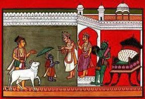
9.1. There is also a talk of another migration at a later era. It relates to the migration of the Brighus – the Yadus from the Saraswathi and Narmada regions to far south and to Sri Lanka. And, that has to do with the Bali – Vamana legend.
9.2. The Mahabali – Vamana episode is at times explained in the context of Brighu- Angirasa rivalry. Maha-Bali (aka Indrasena) the son of Virochana and the grandson of the legendry devote-prince Prahlada, was an Asura. Shukra the son of Brighu was his preceptor. The king Mahabali, whose preceptors were the Brighus, ruled and controlled vast area called Brighu Desha or Brighu Kakshya – the domain of the Brighu (Brighu kaccha – Baruch) that covered the west, the north-west and the south west of the Indus. He performed a sacrifice on the southern banks of the Narmada situated in Brighu Kakshya.
9.3. Vamana represents the arrival of Angirasas into the kingdom of Mahabali. Vamana the son of sage Kashyapa, in the linage of the Angirasa, initially asked the king for a small piece of land for their settlement; and the king consented to his request despite warning from his priest (Shukra). The Bhargava Shukra seemed to be aware of the designs of the Angirasas. The Kashyapas, starting from their small settlement, spread throughout the kingdom of Mahabali and eventually overthrew him from his kingship. The story of Vamana, perhaps, signifies the transfer of power from the Asura kings and their Brighu priests to the Devas and their Angirasa priests.
9.4. The Brighus and Yadus who earlier formed the majority in the Bhrigu country were now overwhelmed by the fresh immigrants. They were thereafter resettled – through sea route – by Bhargava Rama (in the linage of the Brighus) along the western coast and in what is now Kerala. The resettled Brighus carried to their lands the legend of their beloved King Mahabali and also the Krishna cult.
[Some of these are views; may not necessarily be verifiable facts. Chronology and ordering the events in sequences is the other issue.]

References and Sources
http://assets.cambridge.org/97805217/71115/excerpt/9780521771115_excerpt.pdf
http://www.tamilwritersguild.com/edited_Ilamurid.pdf
http://www.indianetzone.com/47/pandyas.htm
http://www.harekrsna.com/sun/features/01-10/features1629.htm
http://bulfinch.englishatheist.org/flood/Indian-Flood1.htm
https://www.jstor.org/stable/41694126?read-now=1&seq=1#page_scan_tab_contents
https://www.ancient.eu/article/1259/naval-warfare-in-ancient-india/
All pictures are from Internet

sreenivasaraos
March 18, 2015 at 7:51 am
Sreenivasa Rao Sb,
Simply excellent and outstanding. I did put this blog on favorites for future reference. In fact I stopped telling the story of Harappa after the second part because I needed more supporting material. I will see if I can reopen that story now.
Thanks,
DMR Sekhar.
sreenivasaraos
March 18, 2015 at 7:51 am
Dear Shri Sekhar, I am delighted this post interested you. Thank you. Let me see if I can improve its content. Regards
sreenivasaraos
May 5, 2016 at 5:05 pm
I am reproducing here a message received from Dr. Iravatham Mahadevan on 03 Feb 2016
Dear Dr. Sreenivasa Rao
Thank you very much for your mail.
I am glad that you have a copy of my convocation address at the Dravidian University.
I have gone through your blog on the migrations. I judge that it is written by a scholar with deep learning especially in indian mythology, including south Indian.
Your approach brings you within my target audience of scholars who can follow bilingual parallels in Dravidian and Indo Aryan.
I therefore take the liberty of attaching a recent paper of mine – Dravidian Proof of the Indus Script via the Rig Veda: A Case Study. I consider it to be the most productive paper written by me.
I shall be grateful if you can send me your residential address for me to post hard copies of my future publications.
Regards
I. Mahadevan